NAVIGATION INTRODUCTION
The Method of Navigation
There are three main methods of air navigation. There are
[SIZE=3]
1. Pilotage 2. Dead Reckoning 3. Radio.
Pilotage or Piloting is the most common method of air navigation. This method, the pilot keeps on course by following a series of landmarks on the ground. Usually before take-off, pilot will making pre-flight planning , the pilot will draws a line on the aeronautical map to indicate the desired course. Pilot will nots various landmarks , such as highways , railroad tracks, rivers , bridges . As the pilot flies over each of landmark , pilot will checks it off on the chart or map. If the plane does not pass directly over thelandmark , the pilot will know that he has to correct the course.
[LEFT]Dead Reckoning is the primary navigation method used in the early days of flying. It is the method on which Lindberg relied on his first trans-Atlantic flight. A pilot used this method when flying over large bodies of water, forest, deserts. It demands more skill and experience than pilotage does. It is based on time, distance, and direction only. The pilot must know the distance from one point to the next, the magnetic heading to be flown. Pilot works on the pre-flight plan chart , pilot plan a route in advance. Pilot calculate the time to know exactly to reach the distination while flying at constant speed. In the air, the pilot uses compass to keep the plane heading in the right direction. Dead reckoning is not always a successful method of navigation because of changing wind direction. It is the fundamental of VFR flight.
Radio Navigation is used by almost all pilots. Pilots can find out from an aeronautical chart what radio station they should tune to in a particular area. They can then tune their radio navigation equipment to a signal from this station. A needle on the navigation equipment tells the pilot where they are flying to or from station, on course or not .
[/left]
[/size]
Pilots have various navigation aids that help them takeoff,fly, and land safely. One of the most important aids is a series of air route traffic control , operated throughout the world. Most of the traffic control uses a radar screen to make sure all the planes in its vicinity are flying in their assigned airways. Airliners carry a special type of radar receiver and transmitter called a transponder. It receives a radar signal from control center and immediately bounces it back. When the signal got to the ground, it makes the plane show up on the radar screen.
[SIZE=3]
1. Inertial GuidanceThis system has computer and other special devices that tell pilots where are the plane located.
2.LORAN Long Range Navigation The plane has equipment for receiving special radio signals sent out continuous from transmitter stations. The signals will indicate the plane location
3.GPS Global Positioning System. is the only system today able to show your exact position on the earth any time, anywhere, and any weather. The system receiver on the aircraft will receives the signals from sattelites around the globe.
[/size]
TERMINOLOGYADF Automatic Direction Finder. An aircraft radio navigation which senses and indicates the direction to a Low/Medium Frequency non-directional radio beacon (NDB) ground transmitter.DME Distance Measuring Equipment. Ground and aircraft equipment which provide distance information and primary serve operational needs of en-route or terminal area navigation. EAT Estimated Approach TimeEFIS Electronic Flight Instrument System , in which multi-function CRT displays replace traditional instruments for providing flight, navigation and aircraft system information, forming a so-called " glass cockpit ".ETA Estimated Time of Arrival GPS Global Positioning System . A navigation system based on the transmission of signals from satellites provided and maintained by the United States of America and available to civil aviation users.HDG Heading. The direction in which an aircraft’s nose points in flight in the horizontal plane, expressed in compass degrees (eg. 000 or 360 is North, 090 is East)HSI Horizontal Situation Indicator. A cockpit navigation display, usually part of a flight-director system, which combines navigation and heading.IFR Instrument Flight Rule . prescribed for the operation of aircraft in instrument meteorological condition.ILS Instrument Landing System . consists of the localizer, the glideslope and marker radio beacons (outer, middle, inner). It provides horizontal and vertical guidance for the approach.INS Inertial Navigation System. It uses gyroscopes and other electronic tracking systems to detect acceleration and deceleration, and computes an aircraft’s position in latitude and longitude. Its accuracy, however, declines on long flights. Also called IRS, or Inertial Reference System.KNOT (kt) Standard Unit of speed in aviation and marine transportation, equivalent to one nautical mile per hour. One knot is equal to 1.1515 mph., and one nautical mile equals to 6,080 feet or 1.1515 miles. One knot is equal to one nautical mile per one hour.LORAN C Long Range Navigation is a Long-Range low frequency Radio Navigation. Its range is about 1,200 nm by day to 2,300 nm. by night.MAGNETIC COURSE Horizontal direction, measured in degrees clockwise from the magnetic north. MACH NUMBER Ratio of true airspeed to the speed of sound. Mach 1 is the speed of sound at sea level. Its values is approximately 760 mph.NDB Non-Directional Beacon. A medium frequency navigational aid which transmits non-directional signals , superimposed with a Morse code identifier and received by an aircraft’s ADF.RMI Radio Magnetic Indicator. A navigation aid which combines DI ,VOR and /or ADF display and will indicate bearings to stations, together with aircraft heading.RNAV Area Navigation. A system of radio navigation which permits direct point-to-point off-airways navigation by means of an on-board computer creating phantom VOR/DME transmitters termed waypoints. TACAN TACtical Air Navigation. Combines VOR and DME and used by military aircraft only.System which uses UHF frequencies , providing information about the bearing and distance from the ground station we have tuned into.TCAS Traffic Alert and Collision Avoidance System. Radar based airborne collision avoidance system operating independently of ground-based equipment. TCAS-I generates traffic advisories only. TCAS-II provides advisories and collision avoidance instructions in the vertical plane.TRANSPONDER Airborne receiver / transmitter which receives the interrogation signal from the ground and automatically replies according to mode and code selected. Mode A and B wre used for identification, using a four digit number allocated by air traffic control. Mode C gives automatic altitude readout from an encoding altimeter.VFR Visual Flight Rules. Rules applicable to flights in visual meteorological conditions.VHF Very High Frequency. Radio frequency in the 30-300 Mhz band, used for most civil air to ground communication.VOR Very High Frequency Omnidirectional Range. A radio navigation aid operating in the 108-118 Mhz band. A VOR groun station transmits a two- phase directional signal through 360 degrees. The aircraft’s VOR receiver enables a pilot to identify his radial or bearing From/To the ground station . VOR is the most commonly used radio navigation aid in private flying
VORTAC A special VOR which combines VOR and DME for civil and military used . System provides information about the bearing and distance from the ground station we have tuned into
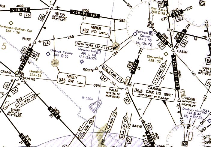
[LEFT]AERONAUTICAL CHART

AERONAUTICAL LEGEND
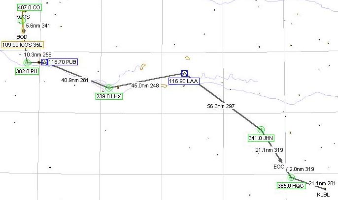
PRE-FLIGHT PLAN CHART
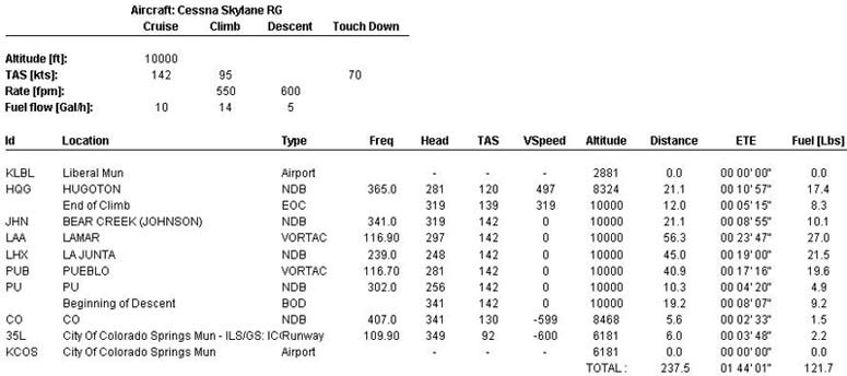
PRE-FLIGHT PLAN CHART DETAIL
منقول
[/left]